Showing posts with label Mexico City. Show all posts
Showing posts with label Mexico City. Show all posts
Wednesday, August 28, 2013

Mexico City - Day 6 part 2 - Anthropology Mueseum
Designed in 1963 by Pedro Ramirez Vazquez, Jorge Campuzano and Rafael Mijares, the National Museum of Anthropology houses an extensive collection on Mexican heritage and culture. The museum has and indoor-outdoor circulation pattern focused on a central courtyard. The main focus of the courtyard is the giant, el paraguas. The umbrella structure covers half of the courtyard and collects rainwater, that showers down and through pavers in the courtyard floor. It also acts as a fountain during drier seasons. Despite some menacing clouds, we did not get to see it in action, unfortunately.


 |
| Museo Nacional de Antropologia - central courtyard |
 |
| El Paraguas - Museo Nacional de Antropologia |
 |
| Pavers at the base of el Paraguas - Museo Nacional de Antropologia |
Sculptural scuppers also bring rainwater into the courtyard. There was some leftover drips from the previous day's rainfall.
 |
| Courtyard pool at the Museo Nacional de Antropologia |
Mexico City - Day 6 part 1 - Chapultepec Park and Aqueduct
Up the hill in Chapultepec's 2nd section, the Carcamo and the Jardin del agua opened as a museum only recently. The structure, a pumping station, dates to the early 1950's as a pumping station for the water supply coming in from the Rio Lerma. The building was designed to direct water from the incoming supply to different reservoirs to serve the city, and it is laden with artwork by Diego Rivera. It operated from the 1950's to the 1990's when it was replaced by underground pipes. By the time the pumping station was decommissioned in the 1990's most of the mosaics and sculpture had been severely damaged by the water flowing through the site.
 |
| El Carcamo with Tlaloc fountain - Chapultepec Park |
The symbolic entrance of water from the Lerma River is marked by a fountain sculpture of the rain god, Tlaloc.


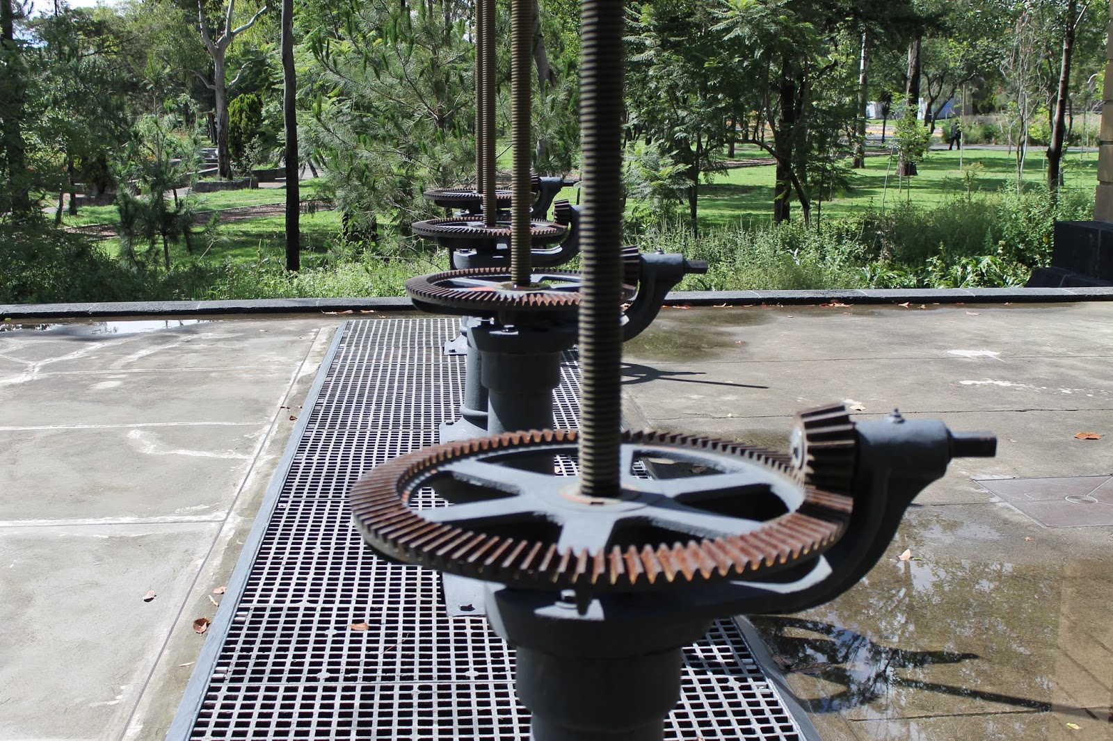
Inside the temple-like structure is the main carcamo chamber which is covered in Diego Rivera murals depicting workers, agriculture and of course, water. The main supply is then split into 4 possible outfalls marked by 4 opening mechanisms inside and outside the building.




Further back in the history of Mexico City's water supply, the springs of Chapultepec were the main supply to Tenochtitlan, the Aztec city and continued to serve the city until replaced by sources from the Lerma River which comes from outside the valley.

The causeway seen in the lower part of the painting contained the Aztec aqueduct from Chapultepec. The aqueduct was replaced in the colonial period. Now, all that remains is a stretch of arches on Av. Chapultepec with fountains on either end signifying the former use.

 |
| a view of the aqueduct from 1902 showing the road and canal beside it. |

Today, the fountain remains, but most of the aqueduct is gone. Following the path of the aqueduct, however, is a bike path. Oddly, I never saw any bikes on this route, possibly because it is in the middle of a major road.

Across from the Salta del Agua is a chapel built for those collecting water from the fountain to give thanks. Like many of the older buildings in El Centro, it is also sinking.

Monday, August 26, 2013
Mexico City - Day 5 - Teotihuacan
This ancient city (pre-Hispanic and even pre-Aztec) sits about 30km northeast of Mexico City. The bus ride from Mexico City takes about an hour. Organized around two major axes, the North-South Avenue of the Dead, and the East-West Rio San Juan (which was diverted to cross the city at this point). The major temples (Pyramids of the Sun and Moon) are on a flat portion of the North-South axis with the Pyramid of the Moon anchoring the North end. After moving past the temple complexes, the Avenue of the Dead slopes down gradually in series of terraces to where it meets the Rio San Juan. The opposite side of Rio San Juan houses the ruined temple of the feathered serpent as well as many of the residential areas of the city.

We arrived in light rain shortly after the park opened. With the weather and the early hour we had the place to ourselves for a while. After climbing the steps of the enormous Pyramid of the Sun, the city's major temple, we took some time to explore some of details.
 The Pyramid of the Sun as seen from the Avenue of the Dead (the city's main North South axis). Dave is in the lower left hand corner of the image for scale.




We arrived in light rain shortly after the park opened. With the weather and the early hour we had the place to ourselves for a while. After climbing the steps of the enormous Pyramid of the Sun, the city's major temple, we took some time to explore some of details.
Masonry work at the corner of the lowest platform of the Sun Pyramid with the Pyramid of the Moon and the Avenue of the Dead in the background. Most likely a restoration work, the angled masonry pieces move water quickly off of the platform as it comes down the side of the pyramid.
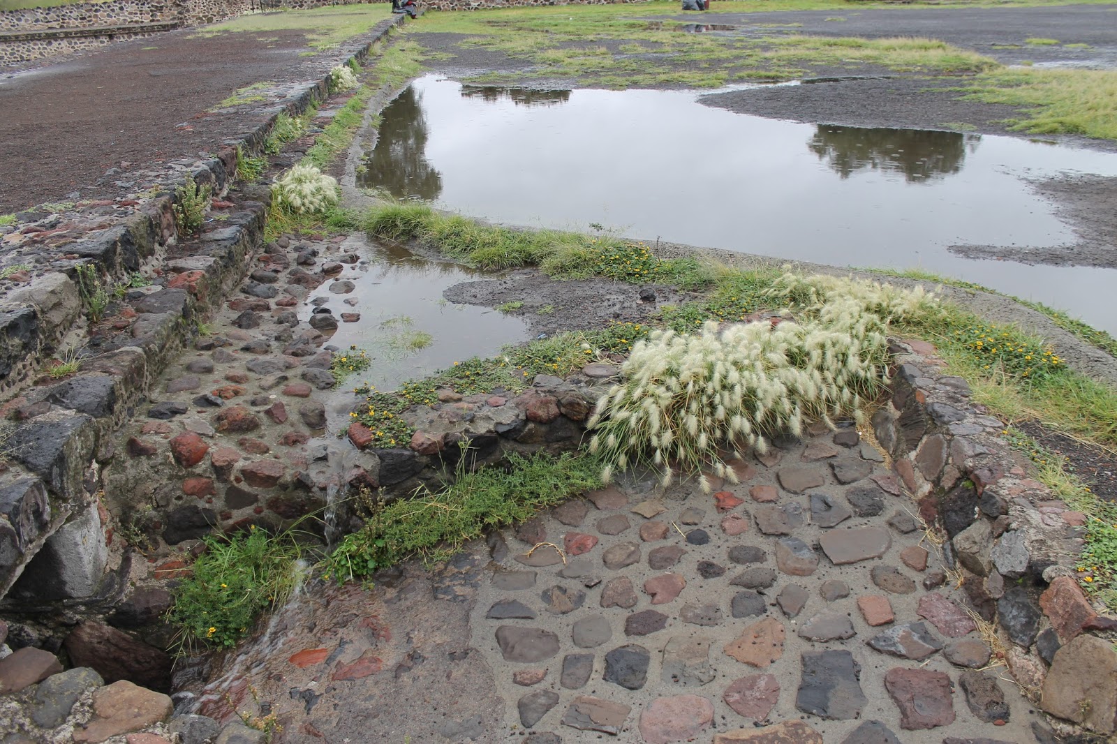
The Avenue of the Dead also contained a sophisticated drainage system. The massive amounts of stone and other impervious surfaces undoubtedly created a lot of runoff. While rain was light while we were visiting, sustained afternoon thunderstorms have been rolling through the Valley of Mexico creating an intense deluge.
The terraces act to collect and slow the movement of water as it runs off buildings and patios toward the Rio San Juan and prevent runoff from washing out everything in its path. The main walkways of the Avenue are raised above this level allowing for continuous use. Drain tunnels connect the terraces and allow water to eventually move out.
The terrace dividers also bring in buried pipes adding runoff from buildings to the side of the Avenue.
The system at work during the morning's light rain.
Sunday, August 25, 2013
Mexico City - Day 3 - Xochimilco part 2
We arrived back in Xochimilco on Saturday morning by tren ligero. The frequent pop and crackle of fireworks signaled that weekend days are a much different experience than the weekday. We were shuffled and directed to one of the embarcaderos where plenty of trajineras were waiting. After a little bargaining in my very limited Spanish, we were off cruising on the canals.


After leaving the embarcadero, the quiet interior of the canals appears. The calm waters are kept that way by the flat-bottomed trajineras propelled only by poles. Boats were numerous out on the canals, mostly families enjoying a relaxing cruise and enjoying the floating food vendors and mariachis that would pull up and offer to play a song.


The buildings facing the canals serve this weekend party atmosphere with restaurants, nurseries (selling some of the many plants grown in the area), and of course W.C.s. raised slightly above the water level.


After disembarking, we explored on foot again some of the area to the East of the center of Xochimilco. This trajinera lift connects two of the canal systems that are at different levels. The process takes a few minutes, but lets the party continue.

In the center of town, the canals only appear as you cross a bridge, but moving out of the center, the canals and roads start to appear in tandem.


These two images taken from the same point, but in opposite directions show how the canal system influenced the later road system: The axis travel remains the same, but the surface material has changed.


Saturday, August 24, 2013
Mexico City afternoon/evening rains
Late afternoon brings daily showers/downpours to Mexico City. They pass through quickly, and cool off the afternoon heat.


After about an hour, the evidence of the rainfall is almost all gone. Almost.....
Mexico City - Day 2 - the edges of Xochimilco on foot
The town of Xochimilco is one of the last remaining examples of the system of canals and chinampas (floating gardens) that were once prevalent around the Valley of Mexico. As Mexico City grew, the canals that once fomed the transit system of Tenochtitlan were filled and as the city expanded further the lake system that surrounded it was drained.
On our fist day in Xochimilco, Dave and I arrived by el tren ligero (light rail) connecting from the main Metro system. Going off the tourist path, we hopped off the train a few stops before the terminus in Xochimilco to explore some of the edges of the canal in the proximity of recent developments.


Intersections with other canals reveal the lush interior of this section. Completely different from what is on the other side of the road:


On our fist day in Xochimilco, Dave and I arrived by el tren ligero (light rail) connecting from the main Metro system. Going off the tourist path, we hopped off the train a few stops before the terminus in Xochimilco to explore some of the edges of the canal in the proximity of recent developments.
Vestiges of the canal system still appear in the surrounding neighborhoods that have been filled: long alleys off the main streets, similar to the irrigation canals off of the major canals.
\
The first impression is not the most picturesque. Work crews were out in full force cleaning up this section of the canals. The adjacent road replaced the transportation function of this canal, but extensive maintenance seems to be required to keep this canal clear of overgrowth.
Continuing on, the residences got noticeably more upscale, with more elaborate crossings over the canal.
Eventually, we meandered to one of Mexico City's largest open bodies of water: the Olympic rowing course from the 1968 games.
Surrounded by a well used walking/biking path the course seems removed from the city. Some livestock help reinforce the agricultural roots of this area.
Upon reaching one end of the 2000m course, the town of Xochimilco is close by, but separated by the Cuemanco canal. Luckily, there is a way across. The trajinera ride takes about a minute, and connects the numerous playing fields and sports clubs around the Olympic course to the town.
Once across the canal, the narrow streets and alleys reflect a scale of living not suited for cars. The ends of roads frequently end up back at the canals which were formerly the only way to move goods and people around.
Back across the canal, past the sports clubs and soccer fields, is the Cuemanco embarcadero. Even though it is somewhat removed from much of the city, it is lively on a Friday afternoon, as both a way to get onto the canals and just a place to hang out.
A walk along the busy Periferico (the ring road that winds its way around the outer edges of Mexico City) brings us to the Parque Ecologico. Built in the early 1990's, the park creates an ecological refuge for many native species and preserves waterways from being filled.
A quick taxi ride takes us back the el tren ligero, and we're back in the city for the night. We will return tomorrow for a trajinera tour and see some of the bigger canals in their weekend form.
Subscribe to:
Posts (Atom)